First off, I wanted to wish everyone a happy new year! The last couple of months really threw a lot of work my way that unfortunately slowed down the writing of this blog. That said, I’m making it a goal this year to release a new blog post on (at least) a bi-weekly basis.
I don’t know about you, but this winter has been a bit of a strange one. I slipped on ice on my driveway on Monday, I could have gotten away with shorts Wednesday, and today I’m worried about freezing rain on my commute home. But the ups-and-downs of Missouri have nothing on what the east coast of the United States experienced last week with Winter Storm Grayson. Reading about the historic storm that region faced last week introduced me to two new terms (though they’ve been in use since the 1980s) – “bomb cyclone” and “bombogenesis.” I initially thought these terms were sensationalist ways of saying “watch out – this storm is going to be huge,” but no! “Bomb cyclone” and “bombogenesis” are really actual scientific terms.
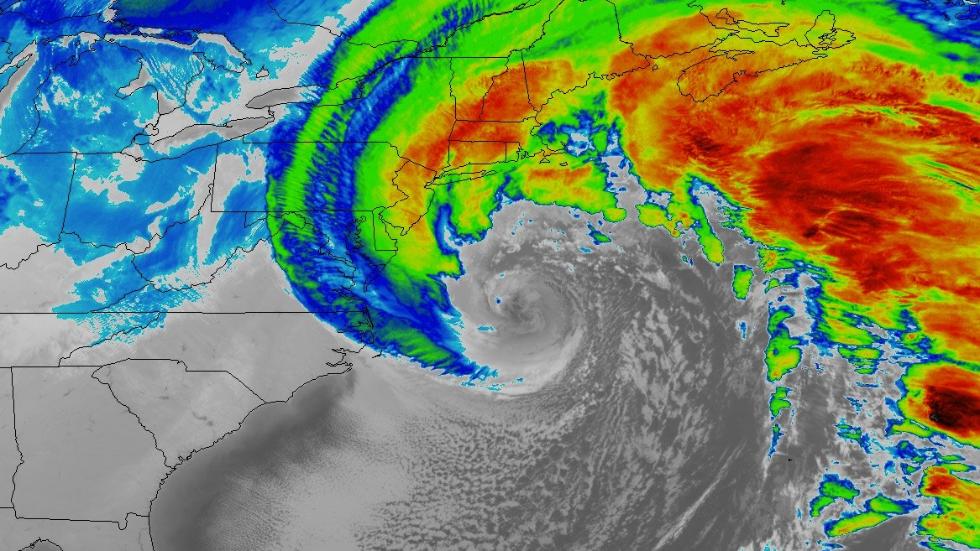
A bomb cyclone occurs when a storm system undergoes bombogenesis, or a central pressure drop of at least 24 millibars in 24 hours or less (1 millibar = 0.0145038 pounds per square inch; 24 millibars = 0.348091 pounds per square inch). The pressure in the center of Grayson dropped 59 millibars (0.855723 psi) in 24 hours! This massive pressure drop occurred as warm, southern air mixed with cold, arctic air brought southward by an unusually large kink in the polar jet stream (a high, quick-moving stream of air that usually keeps colder air in the arctic). The following photo, courtesy of NASA, shows Grayson as it bombs just off the eastern US coastline.

(NASA)
This storm has wreaked havoc all up and down the coast. In Florida, roads were closed due to lack of snow removal equipment and frozen iguanas were falling from trees. Blizzard-force winds, inches-upon-inches of snow, floods, and record breaking cold littered the coastal US from Florida to Maine. For a more in-depth write up of exactly what regions saw what, this article by the Washington Post provides a pretty good summary of its effects.
Learning about the how the atmospheric pressures lead to such a massive storm made me think about how our Weather Globe Barometer would look during this "bomb." The water level in the arm would rise dramatically during the 59mb drop in barometric pressure – much more so than it would rise during an average drop in pressure. Below is a picture illustrating how it would appear.

Written By: Jacob Monash

